
$60,000
Change currencySelect Currency
Antillean Guilder
Argentina Peso
Aruban Florin
Australian Dollar
Bahamian Dollar
Barbadian Dollar
Belize Dollar
Bermudan Dollar
Bitcoin
Brazil Real
Bulgarian Lev
Canadian Dollar
Cayman Islands Dollar
Chile Peso
China Yuan Renminbi
Columbian Peso
Costa Rican Colón
Czech Republic Koruna
Denmark Krone
Dominican Peso
Euros
Fiji Dollar
Ghanaian Cedi
Honduras Lempira
Hong Kong Dollar
Hungary Forint
Iceland Krona
India Rupee
Indonesia Rupiah
Israel Shekel
Jamaican Dollar
Japan Yen
Korea (South) Won
Lebanese Pound
Malaysia Ringgit
Mexico Peso
Mauritian Rupee
New Zealand Dollar
Nicaraguan Córdoba
Nigerian Naira
Norway Krone
Pakistan Rupee
Panamanian Balboa
Peruvian Sol
Philippine Peso
Poland Zloty
Russia Ruble
Singapore Dollar
South Africa Rand
Sweden Krona
Switzerland Franc
Taiwan New Dollar
Thailand Baht
Trinidad & Tobago Dollar
Turkey Lira
United Arab Emirates Dirham
United Kingdom Pound
Uruguayan Peso
US Dollar
Viet Nam Dong
Qatar Riyal
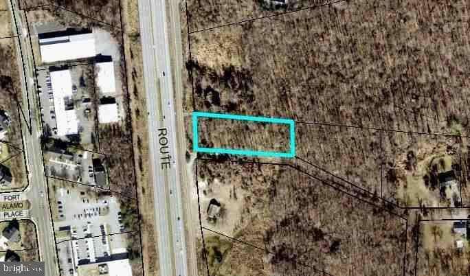
Parcel 6 Indian Head Hwy Fort Washington, MD, United States 20744
The subject property is a 1.00 acre parcel of land that is situated along Indian Head Highway Service Road, a parallel secondary street that runs north/south along Indian Head Highway (Route 210) in Fort Washington, Maryland, in Prince George's County. The property features no assigned street address, referred to in public assessment records simply as ""Indian Head Highway"" and further identified by tax account #05-0301143. The property is a roughly rectangular parcel of raw wooded land that features 145' of frontage along Indian Head Highway Service Road. It is 400' deep with a southern parcel boundary that runs parallel along an unnamed unformed legal road (referred to on some maps as either Christopher Court or Hancock Road) that appears to be a ""paper street"" that was never fully developed to allow for thru-access to neighboring subdivisions. The topography slopes away from the property frontage, gradually through the majority of the parcel. The rear third of the property is traversed north-to-south by a small stream, and in this area signage was observed on the day of inspection that indicates the presence of a WSSC public sewer pipeline on the property. A WSSC representative was able to confirm the presence of a 20' wide pipeline easement is located near the eastern (rear) parcel boundary, which appears to have minimal impact on any potential site utility the subject may have. Attempts to find a plat record for the subject has produced no results, therefore limited information giving greater detail of potential easements related to this pipeline is available. The property is zoned RE - Residential Estate, a zoning classification that permits improvement with single-family detached dwellings at a minimum net lot area of 40,000 square feet. Prince George's County Site, Road & Review Division was able to confirm the presence of public water and sewer utility lines in the vicinity, and the property is indicated on PGAtlas as being in Washington Gas and Pepco service areas. The frontage on Indian Head Highway Service Road directly overlooks Indian Head Highway. While the building potential of the subject is speculative at this time, no significant hindrances to the property's buildability were readily apparent.
Amenities
- Bedrooms: 0
- Full Bathrooms: 0
- Partial Bathrooms: 0
- Property Type: Farm
- Architectural Style: Other
- Home size: 0 ft2 / 0.00 m2
- MLS: MDPG2177296
- Status: Active
Property brokered by
Long & Foster Real Estate Inc.
(703) 877-7800
Presented by Kimberly A Cestari
- (888) 536-0216 (Office Phone)
Contact Kimberly A Cestari

Chicago
161 N. Clark St. Suite 3450Chicago, IL 60601 USA
T : +1-312-424-0400
London
41-43 Maddox StreetLondon W1S 2PD UK
T : +44 020 7467 5330
Singapore
1 Raffles Place,#20-61 Tower 2
Singapore 048616
T : +65 6808 6984
More Info
Sign In